

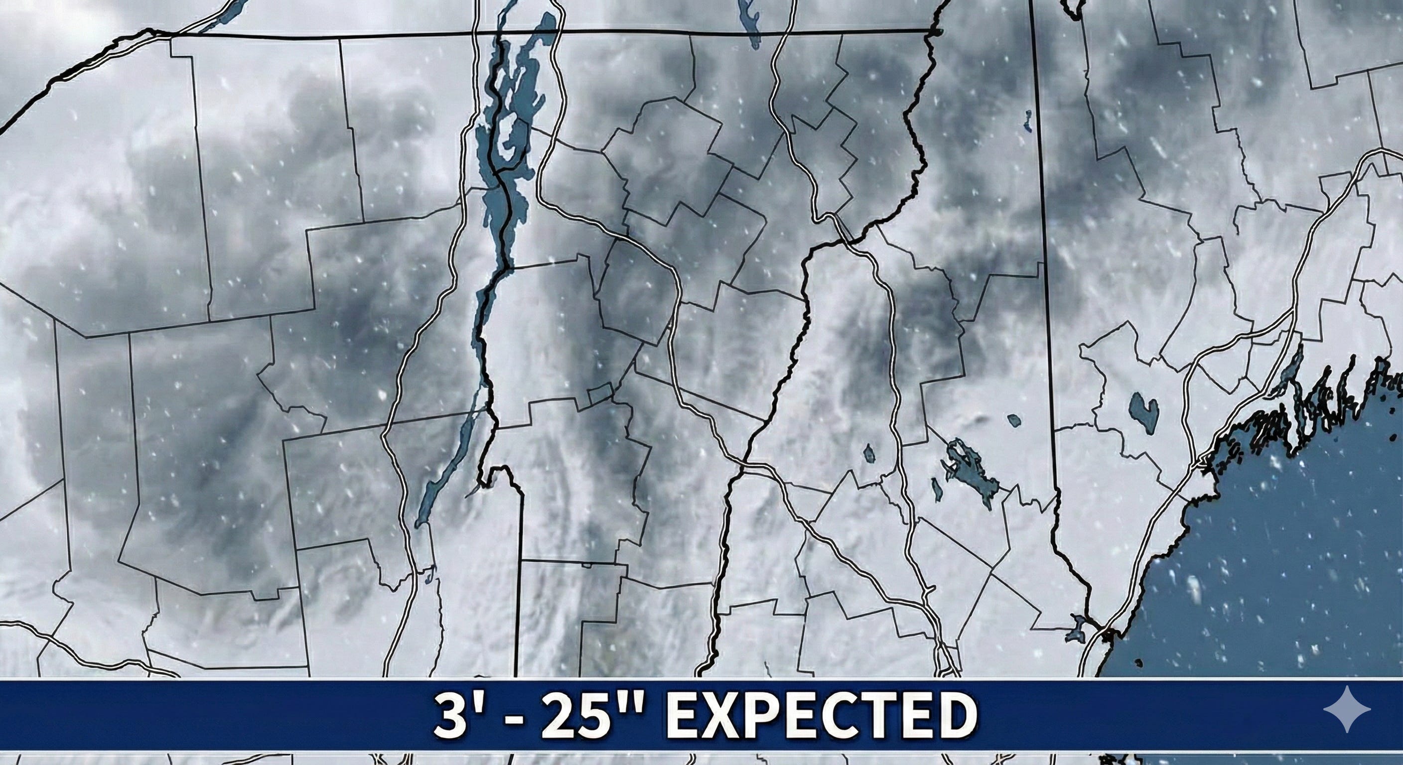
Why Vermont Snow Forecasts Are All Over the Map: 3-25 Inches on Tap — Decoding the Extreme Cold Powder Puzzle
The key concept is the snow-to-liquid ratio. Automated forecasts use a 10:1 ratio, meaning 10 inches of snow for every inch of liquid precipitation. In this storm, snow ratios could reach 25:1.

Arctic Cold Sets the Stage
Vermont is about to experience a meteorological one-two punch. First comes the knockout cold — an Extreme Cold Warning is in effect from 7:00 PM Friday, January 23, until 1:00 PM Saturday, January 24, with wind chill values plunging to 20 to 40 degrees below zero. Then, as that Arctic airmass settles in, a significant winter storm will arrive Sunday afternoon and persist through early Tuesday morning.
The extreme cold currently gripping the state is more than just uncomfortable — it’s the critical setup for what comes next. Wind chill values at Mount Mansfield have already reached 14 degrees below zero, and temperatures are expected to continue dropping. This deep freeze means the ground is thoroughly frozen, ensuring that when snow begins falling Sunday, every flake will stick immediately.
Why Forecasts Range from 3 to 25 Inches
If you’ve been checking weather apps or scrolling through social media, you’ve likely seen wildly different snowfall predictions for the same storm. Some maps show modest accumulations of 3-6 inches, while others depict a major event with up to two feet of snow. The confusion isn’t due to meteorological incompetence — it’s rooted in the unique physics of how snow behaves in extreme cold.
The key concept is the snow-to-liquid ratio, which meteorologists abbreviate as SLR. Most weather apps and automated forecasts use a standard 10:1 ratio, meaning 10 inches of snow for every inch of liquid precipitation. But this Arctic airmass creates conditions ideal for what meteorologists call “dendritic crystal production” — large, lacy snowflakes that stack inefficiently and trap enormous amounts of air.
In temperatures between 10°F and 0°F, snow ratios can reach 20:1 or even 25:1. A Reddit user attempting to clarify the confusion explained it succinctly: “The picture you see... is 10-1 only... take any number on this map in VT and just double it.”
This means a forecast calling for 0.5 inches of liquid precipitation could produce anywhere from 5 inches (using the standard 10:1 ratio) to 12.5 inches (using a more appropriate 25:1 ratio) of actual snow depth. That’s why maps using raw model data without accounting for the extreme cold systematically underestimate the final snowfall totals.
Regional Variations: Not All Vermont Will See the Same Storm
Champlain Valley (Burlington, St. Albans, Middlebury)
The valley floor faces a Winter Storm Watch beginning Sunday afternoon. Snow is expected to develop after 1:00 PM Sunday, with the heaviest rates between 10:00 PM Sunday and 6:00 AM Monday. While lower elevations typically see slightly lower snow ratios (15:1 to 18:1) compared to mountain peaks, widespread plowable snow is expected. The powdery nature means it will blow and drift easily, particularly affecting visibility on open sections of Interstate 89 and Route 7.
Northern Green Mountains (Stowe, Jay Peak, Bolton Valley)
This region represents the epicenter for maximum accumulation. Mount Mansfield’s snowpack currently sits at 69 inches, 25 inches above average, and this storm will add substantially to that base. At 4,000 feet elevation, temperatures will remain in the optimal range for the fluffiest snow, with ratios potentially exceeding 25:1 — true “champagne powder.” The combination of high-ratio snow and orographic lift (air forced upward by the mountains) will maximize totals here, with 12-18 inches as a reasonable baseline and localized amounts approaching 24 inches possible if a persistent heavy band stalls over the peaks.
Central and Southern Vermont (Rutland, Killington, Windsor, Windham, Bennington Counties)
These areas are geographically closer to the coastal low’s center, which often means higher liquid precipitation amounts. Early forecasts indicated southern areas could see “a foot or more,” particularly if the European model solution verifies. The Winter Storm Watch is active for these counties as well.
Northeast Kingdom (St. Johnsbury, Newport, Island Pond)
While slightly removed from the primary moisture source, the Kingdom will remain deeply entrenched in cold air, guaranteeing pure powder. Totals may be modestly lower than the central Green Mountains due to distance from the ocean, but snow quality will be exceptionally dry.
Who to Trust: A Hierarchy of Weather Information Sources
With conflicting forecasts flooding social media and weather apps, knowing which sources to prioritize is essential. Here’s a guide to reliability:
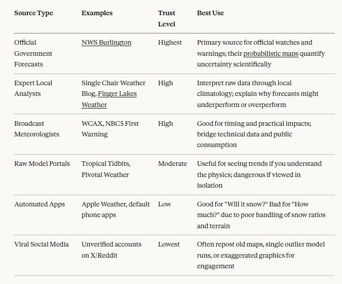
Red Flags for Misinformation - The Giant Blob
Several warning signs can help identify unreliable forecasts. If a map shows a giant solid blob with a single number (like “30 INCHES”) and no range, it’s likely hype rather than science. Real meteorology deals in probabilities and ranges. If a source predicts massive totals but never mentions snow ratios, liquid equivalent, or “fluff factor,” they’re likely guessing rather than applying atmospheric physics.
Always check for timestamps on viral weather maps — images from past historic storms frequently resurface and spread as if they’re current forecasts. And remember that a single model run represents one possibility out of many; reliability comes from ensemble consensus, not individual model outputs.
The Storm Timeline
Friday Evening Through Saturday Afternoon: The Arctic Freeze
The immediate threat is thermal, not snow-related. Wind chills of -20°F to -40°F create frostbite conditions in under 30 minutes. Road salt becomes ineffective at these temperatures, meaning even minimal snow showers from lake effect activity will create slick conditions. This is the critical window for ensuring heating systems are functional and emergency supplies are stocked.
Sunday Afternoon: The Onset
Light snow begins spreading south to north after noon. Road surface temperatures remain well below freezing, meaning the first flakes will stick immediately. Unlike spring storms where roads stay wet for hours, roads will become slick quickly. Travel remains viable in early afternoon but will deteriorate rapidly.
Sunday Evening Through Monday Morning: Peak Intensity
The heaviest snowfall rates occur between 6:00 PM Sunday and 6:00 AM Monday, with possible rates of 1-2 inches per hour. Visibility will drop near zero at times. The lightness of the snow means plows will struggle to keep roads clear as winds of 10-20 mph constantly redeposit snow back onto cleared surfaces through drifting.
Monday Afternoon: Taper and Cleanup
As the system pulls into the Canadian Maritimes, precipitation tapers in the valleys while orographic upslope snow continues in the mountains. The snow will be easy to shovel due to its light weight but voluminous, and continued drifting will complicate cleanup efforts.
Most Likely Outcome: What the Numbers Actually Mean
Based on current model consensus and expert interpretation, here’s what Vermonters should realistically expect:
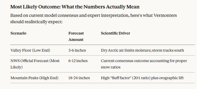
The National Weather Service’s baseline forecast of 6-12 inches for most areas represents the most probable outcome, but the extreme variability comes from two factors: the exact track of the coastal low (which determines moisture availability) and the specific snow ratio at different elevations (which determines how that moisture translates to depth).
Understanding that 12 inches of this Arctic powder weighs far less and occupies far more space than 12 inches of typical March “cement” snow is crucial for preparation. This will be a travel and logistics event rather than an infrastructure destruction event — the Winter Storm Severity Index indicates high impact from snow amount and blowing snow, but minimal threat from ice accumulation or snow load on roofs.
What Happens Next
The National Weather Service will continue updating forecasts every six hours, with the potential for the Winter Storm Watch to be upgraded to a Winter Storm Warning if confidence in warning-level snow (7+ inches) increases. The most critical forecast updates will occur Saturday evening and Sunday morning as the coastal low begins developing.
Vermonters should complete all necessary travel and resupply missions by noon Sunday. The Monday morning commute will be severely impacted statewide, with valley communities facing difficult travel and mountain regions potentially seeing impassable conditions.
For those seeking real-time updates, the NWS Burlington forecast office remains the authoritative source for official warnings and timing. Local expert forecasters provide valuable context for understanding how the official forecast might play out in specific microclimates across Vermont’s varied terrain.
The storm represents a significant winter weather event driven by the collision of Atlantic moisture with a high-quality Arctic airmass — but not an unprecedented one. With proper preparation and realistic expectations about both the snow depth and its unique characteristics, Vermonters can navigate this event safely while enjoying the exceptional powder conditions it will create for winter recreation once roads are cleared.
If Jim Cantore was coming to the area,we'd know we were in trouble... :)
Windham and Bennington counties are still part of Vermont. What about them, or is this just sloppy reporting?