

Vermont’s New Wetland Maps Are More Accurate. But Does Anyone Know How Much Land Is Left to Build On?
What nobody in state government can tell you is what that means — cumulatively — for Vermont’s ability to build the housing it desperately needs.

The Vermont Department of Environmental Conservation made an announcement last week that landed quietly in most inboxes: updated wetland maps for 150 Vermont towns, covering more than 45% of the state, are now open for public comment.
The maps are more accurate than what they replace. The technology is better. The aerial imagery is sharper. And they almost certainly show more wetland territory than before.
What nobody in state government can tell you is what that means — cumulatively — for Vermont’s ability to build the housing it desperately needs.
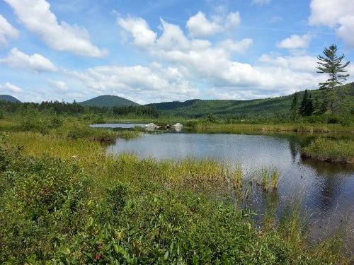
What the Maps Actually Show
The DEC's Vermont Significant Wetlands Inventory (VSWI) maps, last updated for much of the state more than 30 years ago, are being rebuilt using modern aerial imagery and a methodology called NWI Plus. The mapping work is being performed by GeoSpatial Services at Saint Mary's University of Minnesota. The new maps cover the Connecticut River Basin and Northern Lake Champlain Basin — a sprawling list of towns across Caledonia, Windham, Windsor, Essex, and Grand Isle counties.
DEC Wetlands Program Manager Laura Lapierre said the old maps “missed a significant amount of wetland area.” That framing points in one direction: the new maps are larger, not smaller.
The only basin where DEC has published quantitative results — the Otter Creek Basin, updated in 2025 — showed a roughly 20% net increase in mapped wetland acreage. Existing boundaries were refined in some areas, but new wetland territory was added at a significantly higher rate than old territory was removed.
Lapierre offered an important caveat in response to questions from Compass Vermont: VSWI maps show approximate locations, not legal boundaries. Actual wetland boundaries must be confirmed in the field. And permits can be issued for impacts to wetlands when no practicable alternative exists and impacts to wetland function can be managed. “It may not be appropriate to consider an analysis with the layers you mention as the ‘developable land,’” she wrote.
That’s a fair point. It is also true that in practice, a newly mapped wetland — even an approximate one — triggers a permitting process that takes three to six months, requires property owners to hire qualified wetland scientists, and adds thousands of dollars in carrying costs to any project. For a state trying to build 24,000 to 41,000 new homes by 2030, those are not trivial frictions.
Act 121: Flood Law, Conservation Fingerprint
The mapping updates are required by Act 121, the Flood Safety Act, signed into law in May 2024 after the catastrophic July 2023 floods that damaged more than 4,000 homes, 800 businesses, and caused over $200 million in infrastructure damage. The statutory deadline for complete statewide mapping is January 1, 2030. With 80% of maps now in draft or recently finalized, DEC’s claim of being “ahead of schedule” is credible — though draft maps open for public comment are not the same as completed, formally adopted VSWI updates.
Act 121 passed the Vermont Senate 24-4. Every major Vermont conservation organization publicly supported it, including the Vermont Natural Resources Council, Conservation Law Foundation, The Nature Conservancy, and the Lake Champlain Committee. Governor Scott allowed the bill to become law without his signature — a notable choice that stopped short of a veto — and warned it could “put Vermonters in jeopardy of violating laws they don’t even know exist.” His agency secretary called the mapping timeline unrealistic and the funding insufficient.
The flooding rationale is genuine and the science is sound. Researchers have documented a 60% increase in extreme precipitation events in the Northeast since 1958. Wetlands store floodwater. Mapping them accurately serves a real public interest.
The question is whether anyone has calculated what all of Vermont’s overlapping land-use constraints — taken together — mean for the state’s ability to house its people.
Seven Layers, No Cumulative Map
Vermont restricts or disincentivizes development through at least seven distinct regulatory and conservation mechanisms: designated wetlands and their buffer zones; floodplains and river corridors; Act 250 jurisdiction tiers; lands under conservation easement; Current Use enrolled parcels; state-owned forests, parks, and wildlife management areas; and municipal zoning restrictions.
Each of these programs has its own map, its own administering agency, and its own data set. None of them has been integrated into a single, cumulative analysis showing how much Vermont land falls outside all of those constraints simultaneously.
Compass Vermont asked that question directly to several state agencies and industry groups this week.
Kyle Tetzlaff, CEO of the Vermont Association of Realtors, said he was not aware of such an analysis — and asked to receive a copy if one was found.
Laura Lapierre, DEC’s Wetlands Program Manager, said she did not know if such an analysis exists.
Kevin Lambert, responding on behalf of Chris Cochran at the Agency of Commerce and Community Development, pointed Compass Vermont to the Vermont Zoning Atlas and the Vermont Center for Geographic Information — both useful tools that address individual regulatory layers but do not synthesize them into a single statewide picture.
Then Cochran, Vermont’s Director of Community Planning and Revitalization at ACCD — the state official whose job most closely corresponds to knowing where Vermont can build things — responded directly.
“I am aware of several partial datasets,” he wrote, “but they are not integrated into a single, cumulative inventory.”
What That Means
Vermont currently has approximately 230,000 acres of mapped significant wetlands — roughly 3.9% of the state’s 5.9 million acres. DEC estimates that up to 39% of Vermont’s actual wetlands remain unmapped, suggesting the true footprint could be considerably larger once the current update cycle is complete. Add the 50-foot buffer zones that trigger permitting requirements around those wetlands. Layer in floodplains and river corridors. Add the roughly 2.5 million acres — nearly one-third of the state — currently enrolled in Current Use, which financially penalizes conversion to development. Add state forests, parks, and wildlife lands totaling nearly 500,000 acres. Add conservation easements held by land trusts across the state.
No state agency has added those numbers up.
That is the context in which Vermont is trying to build 24,000 to 41,000 homes. The state builds approximately 2,500 per year. More than 50% of Vermont renters are cost-burdened. The rental vacancy rate sits around 3.2%, well below the 4-6% considered healthy. The U.S. Chamber of Commerce estimates the housing crisis costs Vermont more than $700 million in lost economic output annually.
Governor Scott has been pushing in the opposite direction from the mapping expansion. His Executive Order 06-25, issued in September 2025, would reduce wetland buffer zones from 50 feet to 25 feet and limit state permitting requirements to mapped wetlands for housing in designated areas. Environmental groups called it unconstitutional executive overreach. S.266, currently before the legislature, would codify the EO’s wetland provisions by statute — creating a direct legal counterweight to Act 121’s expansion of mapped territory.
Vermont is simultaneously expanding what it maps and contracting what it regulates — without a single document that shows how much land is actually available to build on.
The Public Comment Window
The March 2026 VSWI updates are open for public comment now. Two public meetings remain:
March 23, 2026 at 5:30 p.m. Hartford Town Hall, Meeting Room 2, 171 Bridge Street, White River Junction Virtual registration available at dec.vermont.gov
Property owners, developers, municipalities, and residents in the 150 affected towns can submit comments on the draft maps. DEC has indicated that field verification and corrections are part of the process — the maps are drafts, not final designations.
If your land, your town, or your project is in the Connecticut River Basin or Northern Lake Champlain Basin, the time to engage is now. The interactive map is available at dec.vermont.gov.
Compass Vermont submitted questions to the Agency of Commerce and Community Development, the Department of Environmental Conservation, the Vermont Association of Realtors, and the Agency of Digital Services for this story. All responses are quoted directly and in full above.
Correction: An earlier version of this story attributed the NWI Plus wetland mapping work to the University of Vermont Spatial Analysis Lab. The mapping is performed by GeoSpatial Services at Saint Mary’s University of Minnesota. Compass Vermont thanks the Vermont Agency of Natural Resources for the correction.
Hi Tom -- I read your other piece and will comment there (later). We need to have more imagination and look at our environment not as a constraint but as a context. How do we achieve our objectives without sacrificing our environment? Our state is great in part because of its vast natural resources, its small towns, its community. We risk devaluing/sacrificing our core differentiators.
It is not just a matter of having land to build on — it is a matter of having suitable land to build on. Building very near wetlands increases the risk of wet basements and increased foundation damage through settlement of soils.
Roads near wetlands also can face problems with erosion which costs towns or property owners ongoing maintenance repairs.
And wetlands are an essential part of our environment because they naturally store floodwater, filter pollution, support diverse wildlife, and lock away carbon, even if their presence can sometimes limit where and how we build.
I suggest we re-think how we develop/redevelop not just where we develop.