

Vermont's Housing Framework "Cannot Reasonably Meet Our Needs," Municipal League Tells Legislature
New state analysis puts a precise number on Vermont's regulatory reach — and the Vermont League of Cities and Towns says the current framework cannot support the housing Vermont needs.

One week after Compass Vermont first reported that Vermont has set ambitious housing targets without publicly reconciling whether its regulatory framework leaves enough land to meet them, new data presented to the Vermont Legislature puts a precise number on the problem — and Vermont’s leading municipal advocacy organization is telling lawmakers the current system isn’t working.
In testimony before the House Committee on Environment on Thursday, April 9, 2026, the Vermont League of Cities and Towns delivered a pointed assessment of Act 181’s implementation: “Under these conditions, Tier 2 cannot reasonably meet our needs for rural infill that includes all housing types. Act 181 as passed would not support historic settlement patterns.”
That statement, from an organization representing 251 member municipalities including incorporated villages and other local government entities, came alongside the first publicly cited state analysis quantifying how much of Vermont’s land mass falls under new regulatory jurisdiction — and the number is striking.
The Number
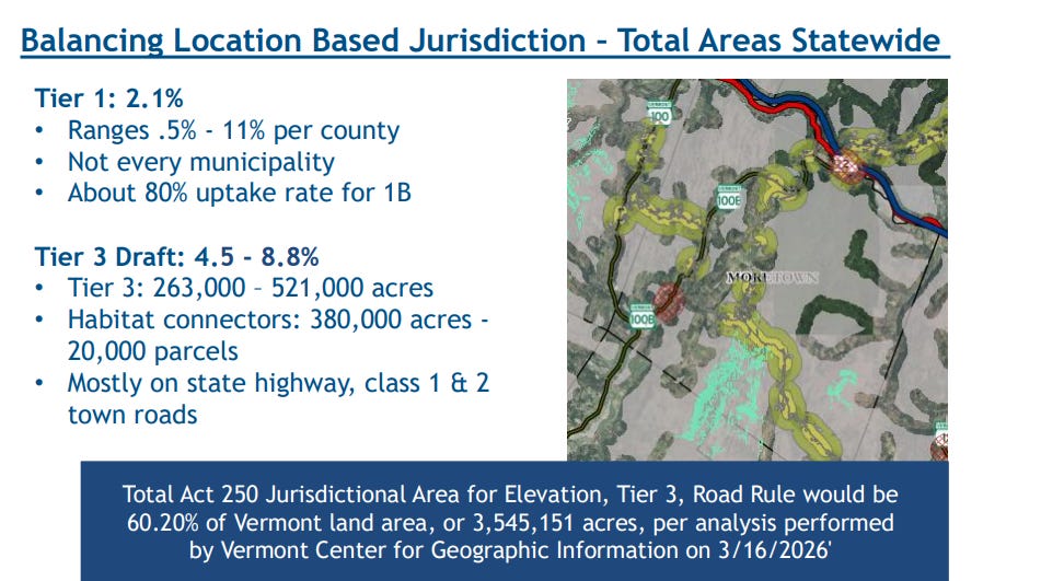
According to an analysis performed by the Vermont Center for Geographic Information on March 16, 2026, and cited in VLCT’s legislative testimony, the combined effect of Act 181’s road rule, Tier 3 mapping, and elevation provisions would subject 60.20 percent of Vermont’s land area — approximately 3,545,151 acres per VCGI’s GIS measurement — to new Act 250 jurisdiction.
Compass Vermont first reported the existence of this analysis last week, based on information provided by VLCT’s Samantha Sheehan, Municipal Policy and Advocacy Specialist, who characterized it as an internal Department of Housing and Community Development analysis estimating a range of 50 to 60 percent. The Vermont Center for Geographic Information analysis cited in Thursday’s testimony puts the confirmed figure at the top of that range and above it.
The same testimony confirmed that Tier 1 eligible areas — the villages, downtowns, and city centers where Act 181 concentrates growth — cover just 2.1 percent of Vermont’s total land mass, ranging from 0.5 percent to 11 percent by county, according to VLCT’s April 9 presentation.
Put plainly: 2.1 percent of Vermont’s land is designated for growth. 60.2 percent faces new or expanded Act 250 jurisdiction. The remaining roughly 37 percent sits in Tier 2 — where existing Act 250 thresholds apply and the road rule adds new jurisdiction on top.
Tier 2 Is Not Business As Usual
One of the most significant clarifications in Thursday’s testimony was VLCT’s explicit reframing of Tier 2 — the default category covering the vast majority of Vermont’s land mass.
Under Act 181, Tier 2 is not simply the continuation of existing Act 250 rules. The road rule — which subjects projects requiring roads longer than 800 feet or combined road and driveway networks longer than 2,000 feet to Act 250 review — applies in Tier 2 regardless of project size or location. VLCT’s testimony was direct: “Tier 2 is not Act 250 as usual.”
That distinction matters enormously for Vermont’s housing goals. According to Sheehan, regional planners estimate that 40 percent of Vermont’s housing targets — as many as 16,000 homes by 2030 under the upper target — must be built outside Tier 1, in rural areas. The majority of that rural land sits in Tier 2. And Tier 2 just got significantly more regulated.
The Infrastructure Gap Inside the Numbers
Even the 2.1 percent designated for growth faces structural barriers that the raw acreage figure obscures.
To achieve full Act 250 exemption — Tier 1A status — a municipality must satisfy nine distinct statutory requirements under 10 V.S.A. § 6034. A primary hurdle is the requirement that public water and wastewater systems have sufficient capacity to support new development. According to VLCT’s April 9 presentation, only 43 of Vermont’s 251 member municipalities operate such systems.
Only 142 municipalities have adopted permanent zoning and bylaws — a prerequisite for Tier 1B status, per VLCT’s presentation. And according to VLCT, 73 percent of its member municipalities have populations under 2,500, governed largely by volunteer boards without dedicated planning staff — another statutory requirement for Tier 1A designation.
VLCT’s testimony noted an approximately 80 percent uptake rate for Tier 1B among eligible municipalities, per its April 9 presentation. That means roughly 20 percent of municipalities that could seek partial Act 250 exemption have not done so — for reasons that likely include the infrastructure, staffing, and process barriers the statute requires them to clear.
The path to full Tier 1A exemption involves a multi-step process — RPC map development, LURB pre-application review, public hearings, LURB approval, municipal application, another public hearing, another LURB deliberation, and periodic reviews every four and eight years thereafter under 10 V.S.A. § 6034. It is not a process designed for speed.
What Tier 3 Could Reach
Thursday’s testimony also clarified the potential scope of Tier 3 jurisdiction under the current draft rules — and it extends beyond undeveloped forest land.
Under the draft Tier 3 rules presented to the committee, Act 250 review could be required for improvements to existing homes and structures with a footprint exceeding 200 square feet, construction of new wastewater and drinking water systems, new homes regardless of size, and roads, driveways, and utilities beyond 50 feet of an existing road, according to VLCT’s April 9 presentation.
Tier 3 draft mapping currently covers between 4.5 and 8.8 percent of Vermont’s land area — between 263,000 and 521,000 acres, per VLCT’s testimony. Habitat connectors alone account for 380,000 acres across 20,000 parcels, mostly along state highways and Class 1 and 2 town roads.
Those are not remote wilderness parcels. They are working landscapes along the roads where Vermont’s rural communities actually exist.
The Permitting Burden
VLCT’s testimony included a project permitting flowchart showing the full regulatory web a Vermont developer navigates — simultaneously managing town development review, state Agency of Natural Resources permits, Act 250 criteria review across more than a dozen criteria, federal permits, and appeals pathways through the Environmental Division of the Vermont Superior Court (formerly Vermont Environmental Court), the Vermont Supreme Court, and federal court.
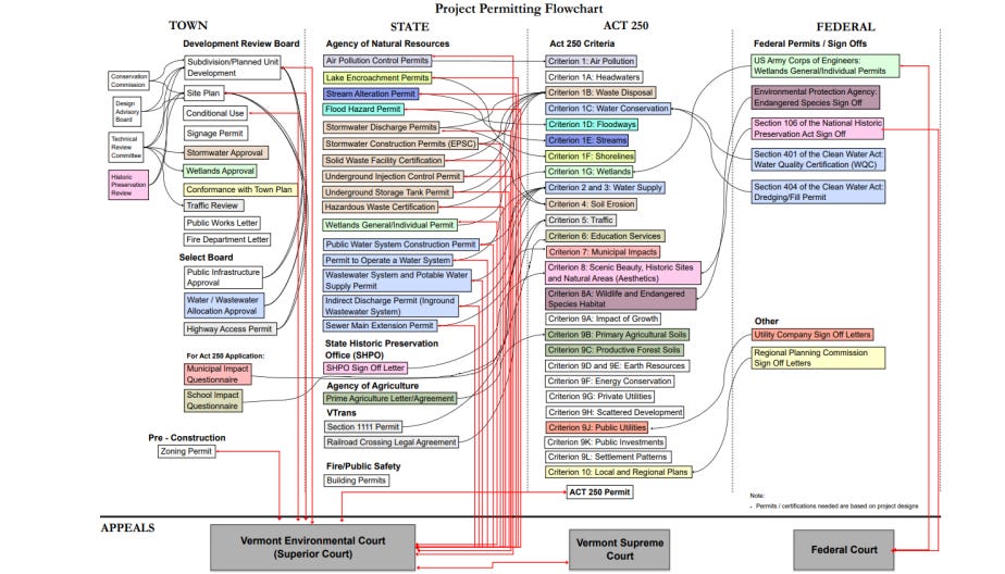
The flowchart reflects Vermont’s existing permitting complexity before Act 181’s additions. But its inclusion in testimony advocating for S.325 makes an implicit argument that VLCT has stated explicitly: the system was already complex, and Act 181 as currently implemented extends that complexity to more places and more projects.
Where S.325 Fits
VLCT’s testimony was presented in support of S.325, the bill currently before the House Committee on Environment that would delay road rule implementation until 2030, push Tier 3 rulemaking to 2028, and delay implementation of Criterion 8C — a new natural resource standard — until 2028 as well.
VLCT’s support for S.325 is not opposition to Act 181’s goals. The organization’s stated priorities are ending duplicative permitting, building more housing, and ensuring municipalities have the tools to manage growth in their communities. Their argument, delivered to the House committee Thursday, is that Act 181 as currently implemented undermines all three.
The five questions VLCT posed to the committee in its closing slides frame the challenge ahead: Where does Act 250 review provide a public good versus where is it duplicative or burdensome? Where can Act 250 relief promote smart growth and support local plans for growth? What is a suitable scale of development for Act 250 review? How can Act 250 be improved to reduce subjective review and improve predictability? And how should citizen-led municipal planning processes be utilized in determining location-based jurisdiction?
Those are not questions with easy answers. They are also not questions Vermont had answered before setting its 2030 housing targets.
What This Means
Last week Compass Vermont reported that Vermont needs to build between 27,867 and 41,185 homes by 2030 — at nearly five to seven times its recent annual production rate — and that no unified statewide analysis existed showing the regulatory framework could support that goal.
This week, the Vermont Center for Geographic Information analysis confirms that 60.2 percent of Vermont’s land faces new or expanded Act 250 jurisdiction. VLCT confirms that Tier 1 covers 2.1 percent of the state. And the organization representing Vermont’s municipalities is telling the legislature directly, as formal legislative testimony, that the current framework cannot support the rural housing Vermont needs.
The gap between Vermont’s housing goals and its regulatory reality is no longer an analytical inference. It is an assessment delivered as formal legislative testimony to a committee with direct jurisdiction over the bill that could change it.
S.325 is before the House Committee on Environment. H.775 is before the Senate Committee on Economic Development, Housing and General Affairs. The 2030 deadline does not move.
This story is part of Compass Vermont’s ongoing investigation into Vermont’s housing capacity and land use framework. Read the original story here. Contact news@compassvermont.com with tips or information.
Thank you for your analysis, my dad and I were just discussing these 3 numbers, so I’m thankful for you sharing these.
But the most important question and answer is still unclear: what percentage of households (not land) fall under the 3 tiers? 2.1% for Tier 1 looks unimportant, but the density of Tier 1 locations are much denser than Tier 2 or Tier 3. How much denser? Vermonters need that data to assess the impact on ourselves, not just land percentages.