

Vermont's Crossroads: Why Forecasters Are Split on the 2025-2026 Winter Season
NOAA’s own projections show the confidence in La Niña persisting through the core winter months drops to just 54%—barely more than a coin toss.

If you’ve heard conflicting reports about the upcoming winter, you’re not alone. This year, the forecast for Vermont is a genuine meteorological puzzle, with major forecasting groups looking at the same global signals and arriving at starkly different conclusions. The central issue is a tug-of-war between two powerful forces: the historical tendency for a La Niña pattern to bring cold and snow, versus the undeniable reality of a long-term climate warming trend that favors milder winters.
The result is a season loaded with uncertainty, but by understanding the key players and the “wildcard” factors at play, Vermonters can get a clear picture of why the experts are divided and what the most likely outcomes are for the Green Mountain State.
The Global Headliner: A Faint La Niña
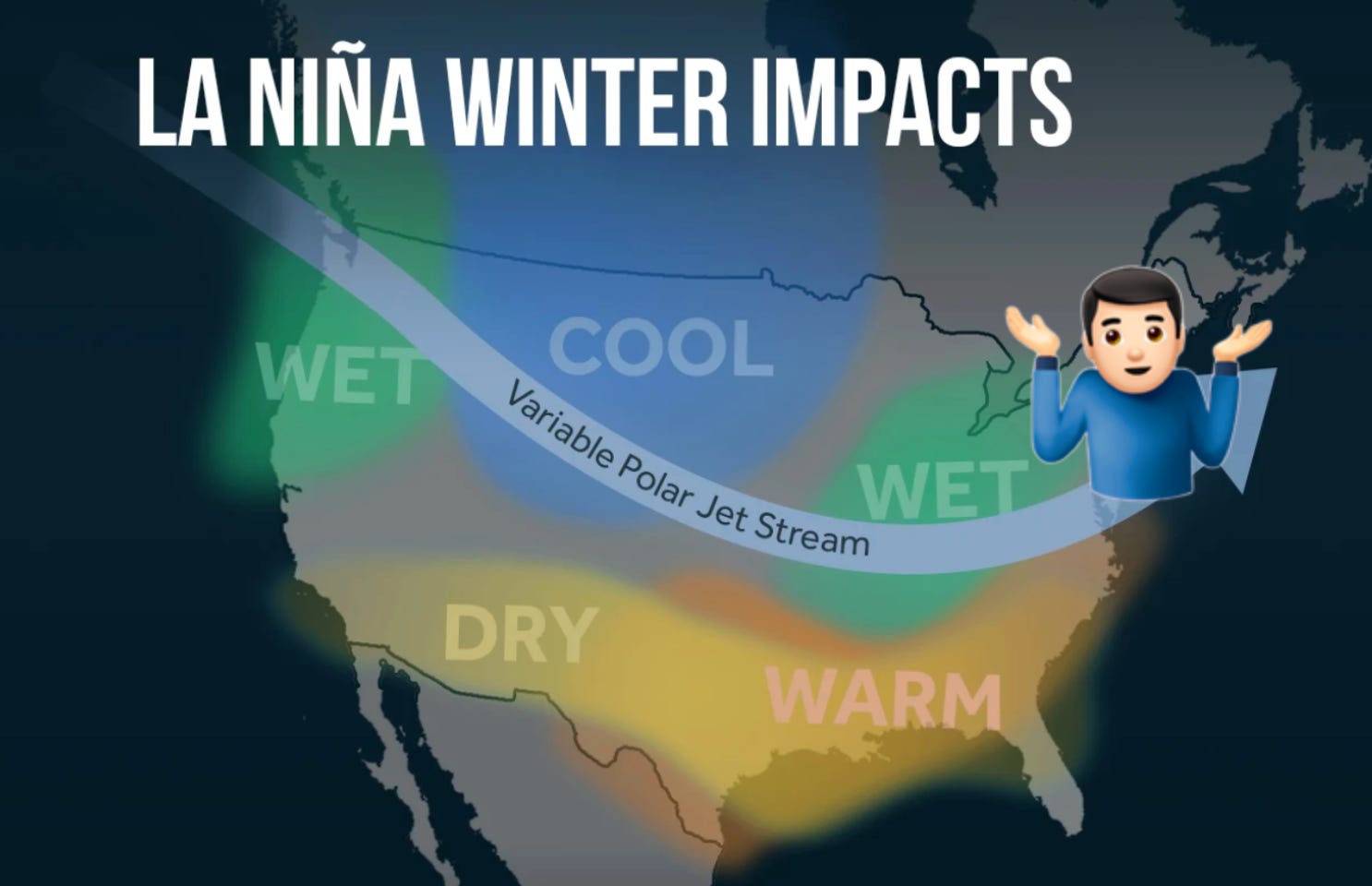
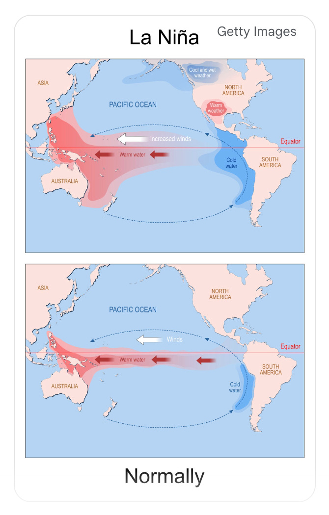
Every long-range winter forecast starts in the tropical Pacific Ocean. This year’s main climate driver is a developing La Niña, the cool phase of a natural cycle that can powerfully influence weather across North America. Think of it as the cool phase of the Pacific’s heartbeat. According to the National Oceanic and Atmospheric Administration (NOAA), a “La Niña Watch” is in effect, with a strong 71% chance of it forming this fall.
But here’s the crucial detail: it’s expected to be a weak and potentially short-lived event. NOAA’s own projections show the confidence in La Niña persisting through the core winter months drops to just 54%—barely more than a coin toss. This weakness is key. A strong, locked-in La Niña can dominate the winter pattern, but a faint one like this leaves the door wide open for other factors to take control.
A Tale of Two Forecasts: The Major Disagreement
This weak La Niña signal is the primary reason for the deep split among forecasters. They are essentially placing their bets on which force will win out: La Niña’s history or the climate’s recent trend.
The “Warm Winter” Camp
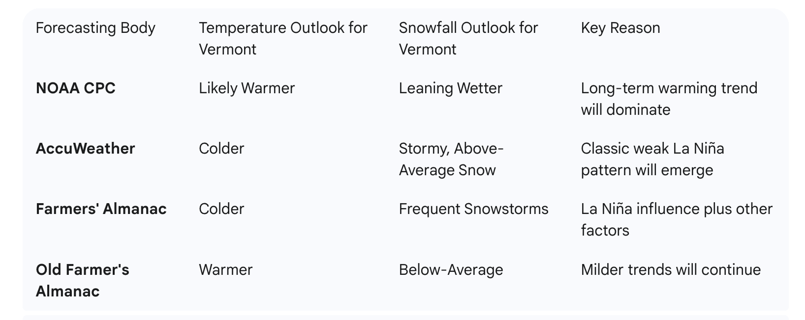
Leading this group is NOAA’s official Climate Prediction Center (CPC). Their winter outlook shows a very high (70-90%) probability of a warmer-than-normal winter for Vermont and the entire Northeast. They also predict a “leaning above normal” chance for precipitation.
Why are they so confident? Their models are heavily weighing the powerful, long-term winter warming trend in our region. In their view, the background climate is now so warm that it will simply overpower the weak cooling influence from this La Niña. The Old Farmer’s Almanac agrees, also calling for a milder-than-average winter with below-average snowfall.
The “Cold and Snowy” Camp
In direct opposition, AccuWeather is calling for an “intense and stormy winter” with colder-than-average temperatures and above-average snowfall, especially in the mountains. They point to a classic weak La Niña pattern, which historically has been a good snow-producer for northern New England. Their forecast specifically highlights an increased risk of nor’easters and a potential major Arctic outbreak in February. Similarly, the Farmers’ Almanac, under the theme “Chill, Snow, Repeat,” is forecasting a harsh winter with frequent storms and significant cold snaps.
The Wildcards: What Could Tip the Scales?
So, who is right? The answer may lie with a few lesser-known atmospheric phenomena that act as winter’s “wildcards.” While La Niña sets the background stage, these factors often dictate the actual weather we experience week-to-week.
The most important wildcard this year is the Polar Vortex. This is a large area of very cold air that spins over the North Pole. When it’s strong and stable, the cold air stays locked up in the Arctic. But if it weakens or gets disrupted, it can wobble and send lobes of intensely cold Arctic air plunging south into our region—this is how we get our most severe cold snaps.
According to severe weather researchers, there is a predictable high-altitude wind pattern called the Quasi-Biennial Oscillation (QBO) that is forecast to be in a phase that is scientifically linked to a weaker, more easily disrupted Polar Vortex. This provides a strong physical reason to believe the “colder” forecasts have merit. It doesn’t guarantee a cold winter, but it does mean the atmosphere is pre-conditioned for a potential breakdown of the polar vortex, which would unleash a major Arctic outbreak.
The Bottom Line: What This Means for Vermonters
After weighing all the evidence, a single, persistent pattern of either warmth or cold seems unlikely. The most probable outcome is a winter of high variability and sharp swings.
Temperature: Expect a rollercoaster ride. The season is likely to average out near or slightly above normal, but that average will mask significant volatility. A milder start to the season is possible, followed by a heightened risk of a major, multi-week Arctic blast in the second half of winter, most likely in February, when a polar vortex disruption becomes more probable.
Precipitation & Snowfall: The good news for winter enthusiasts is that an active storm track is expected, meaning we should see frequent storm systems. The critical question will be temperature.
For the Mountains & Ski Areas: The forecast is favorable. The active storm track combined with higher elevations should result in near- to above-average snowfall. Resorts along the spine of the Green Mountains are well-positioned to benefit. ⛷️
For the Valleys (Champlain, Connecticut River): This is where the forecast is toughest. While storms may be frequent, the warmer background temperatures mean a constant battle along the rain/snow line. There is a higher risk for messy mixed-precipitation events (sleet, freezing rain) or storms that change to rain, making final snowfall totals highly uncertain and likely closer to average.
Ultimately, this winter is shaping up to be a dynamic one where the final outcome won’t be known until the season is well underway. The weak La Niña provides a shaky foundation, leaving the door open for the wildcards to steal the show and deliver a memorable, high-impact winter for Vermont.