


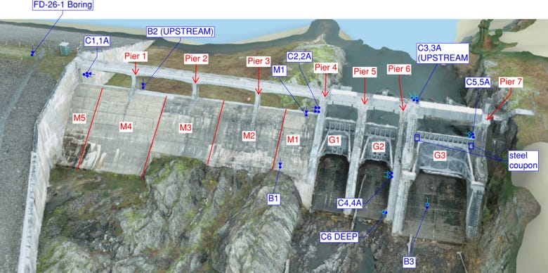
Crews working for the U.S. Army Corps of Engineers are drilling into the Waterbury Dam spillway through the end of October, collecting information engineers need to finish the design of a $76.2 million rebuild of the dam’s flood gates.
The rebuild would let the dam hold back more floodwater than it is allowed to hold today. Since the 2000s, when its flood gates began jamming, the state has capped how high water may rise against them.
What the project costs Vermont depends on Congress. If Congress raises the federal ceiling and funds the project to it, the state needs about $1 million beyond the $4.5 million it has already committed. If no more federal money arrives, the Vermont Department of Environmental Conservation told Compass Vermont, the gap the state would need to cover comes to roughly $30 million.
If you use Waterbury Reservoir or live along the Little River or the Winooski below the dam: at the bottom of this story, how to sign up for DEC’s notices on the reservoir drawdown and construction schedule, and how to look up the mapped river flood hazard at your own address.
What the dam does
The Waterbury Dam holds back the Little River above its meeting with the Winooski. The Corps designed it after the 1927 flood, and it was finished in 1938. It stands 187 feet tall and runs 2,100 feet long, and DEC credits it with preventing about $4 million in flood damage a year, according to a February 2026 presentation to the House Corrections and Institutions Committee.
The state rates it high hazard. That rating describes what a failure would cost, not how likely a failure is: DEC estimates about 5,000 people and 1,400 structures sit in the area a failure would flood.
The dam also supports Green Mountain Power’s 5-megawatt hydro plant and the boating and camping at Little River State Park and Waterbury Center State Park.
The spillway is the dam’s controlled overflow channel, built to carry off water the reservoir cannot hold rather than let it spill over the earthen dam itself. Waterbury’s spillway has three curved steel flood gates. Each gate swings on a pair of steel arms that pivot on pins set into the concrete, and those arms carry the push of the water against the gate.
The limit on the flood gates
Engineers track the reservoir by elevation, its height in feet above sea level. The flood gates sit at elevation 592 and reach to about 618. They were designed to operate up to elevation 617.5.
Since the jamming in the 2000s, the state has held that operating limit at 610.8, which DEC describes as roughly two-thirds of the way up the gates. Above that height, running the gates under more water pressure could damage the arms, DEC said in written answers to Compass. So once a flood pushes the reservoir past 610.8, the Dam Safety Program starts opening the gates and letting water through rather than holding it.
The restriction did not shrink the reservoir. What it takes away is the ability to hold floodwater back in the top 6.7 feet of it. Lowering the operating elevation from 617.5 to 610.8 means “the flood attenuation storage is reduced as inflows when reservoir levels are above El. 610.8 would be passed downstream rather than stored as originally designed,” Ben Green, the state’s dam safety engineer, wrote.
The reservoir has not reached 610.8 since the limit went in, DEC said, “but it certainly could during a major storm event.” The July 2023 flood peaked at 604.32, about 6.5 feet below the limit. July 2024 peaked at 601.05. The highest reading on record, however, came in May 1940: 613.45, about 2.5 feet above where the limit now sits.
Temporary fixes along the way
Testing in 2022 found the pivot pin on one arm of Gate 2 slightly crooked, which adds friction. Green said analysis showed the arm would be overstressed if the gate were operated with water above 608.4 feet, 2.4 feet below the limit. The state welded steel plates onto Gate 2’s arms so the gate can run safely up to 610.8.
That was part of about $785,000 in interim repairs DEC dates to spring 2024, which also included steel beams flown in by helicopter to shore up the spillway bridge. The program finished after the July 2023 flood, which peaked about four feet below 608.4.
In September 2025, a routine inspection turned up a problem with the brakes on the motor that raises Gate 3. The state took the gate out of service and switched on the dam’s emergency plan at its lowest, non-emergency level. Crews left the gate fully closed rather than open while a new motor was ordered. It went in in January 2026, for about $20,000. No storm in those four months called for opening Gate 3, Green said.
What the drilling is for
The 1938 concrete and the rock beneath it have not been tested in the detail a final design needs. This fall’s work, run from a barge, a work boat and truck-mounted drill rigs, covers about 15 holes drilled into the spillway concrete, the bedrock and the edge of the earthen dam, plus two steel samples cut from Gate 3, DEC said.
The results tell engineers how much of the concrete piers has to come out, whether the concrete sits solidly on the rock, and whether Gate 3 can be refurbished or has to be replaced. The plan already calls for new Gates 1 and 2, a new bridge over the spillway, new lifting equipment and a concrete apron to keep the river from wearing away the rock below the spillway.
The drilling was scheduled for this past spring. DEC said it moved to the fall because of Corps scheduling and negotiations with the Corps’ consultants “as the scope of the program was refined to be within the project budget.”
Who pays
The price has come down from $92 million to $76.2 million, and the state negotiated its share down from 35 percent of design and construction to 7.1 percent of the project’s cost, according to the February presentation. Asked about a 7.5 percent share and a roughly $50 million federal figure that circulated in early 2025, DEC told Compass that 7.1 percent is the correct rate and that $40 million is the federal money appropriated.
So far $44.5 million is appropriated: $40 million federal and $4.5 million from the state.
The rest turns on two separate acts of Congress.
Federal law sets a general limit of $60 million on what the Army Corps may spend at any one dam under the program Vermont is using, Section 1177 of the 2016 WIIN Act. Since 2024 the Corps has been able to spend above it only by making a formal determination and getting Congress to authorize that specific project.
Congress can also change the number outright, through the Water Resources Development Act, the bill it passes every two years to authorize Corps work. Both chambers have now moved a version, and they do different things.
The Senate’s would write the project into federal law by name. Section 1305 of S. 4949, as reported by the Environment and Public Works Committee, strikes that 2024 exception and puts a single sentence in its place: the Corps “shall not expend more than $90,000,000 under this section for the Waterbury Dam Spillway Project, Vermont.” That is $30 million above today’s limit, and more than the project’s entire $76.2 million estimate — enough that the limit would stop being what holds the money back. The bill has not reached the Senate floor.
The House bill does not mention Waterbury. H.R. 9497, which passed 415-9 on Sept. 16, changes a different number in the same law: the amount Congress authorizes itself to spend on the national dam rehabilitation program each year, which its Section 302(d) raises from $60 million to $80 million. That is the whole program, not this dam.
DEC told Compass this month that WRDA 2026 carries an $80 million authorization for Waterbury. That figure matches the House’s program-wide number rather than the Senate’s project-specific one.
Vermont’s delegation has been down this road once already. In May 2024, Sen. Peter Welch announced that the Senate committee’s water bill that year would authorize $100 million for the Waterbury Dam. That figure did not survive into the law Congress passed. What WRDA 2024 did instead was leave the $60 million limit alone, add the exception the Senate now proposes to replace, and extend the program’s funding authorization through 2030.
An authorization is not money in any case. Congress has to appropriate the dollars separately, and DEC said any added federal money carries the 7.1 percent non-federal cost share with it.
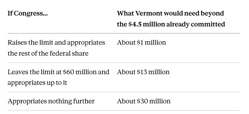
Source: DEC’s February 2026 presentation for the first two figures, DEC’s written answers to Compass for the third. All are DEC estimates, and DEC said the total will get more precise as design advances. The $13 million and $30 million figures are DEC’s. Compass could not reproduce either from the published cost and appropriation numbers, which yield about $11.7 million and $31.7 million.
That last figure is not a bill anyone has voted to pay. It is the hole that would be left in a $76.2 million project, and it is nearly seven times what the state has put in so far.
Asked where the money would come from if the federal share falls short, DEC said it is working with the Scott administration, the Legislature and Vermont’s congressional delegation. It did not name a source.
Construction is penciled in for roughly 2028 to 2030, pending funding, and is expected to take about two years.
What it means for the reservoir
To do the work safely, the state will have to lower Waterbury Reservoir by 30 to 50 feet, with the exact drop set during final design, according to DEC. The drawdown would likely happen over the winter before the first construction season, with work starting that spring. DEC said it does not yet know how long boat ramps, the state parks or the hydro plant would be affected.
Once the project is finished, DEC says, the dam would no longer need the seasonal drawdowns it uses now, which it expects to improve water quality in the reservoir and the Little River.
Check your own situation
Use the reservoir, the boat ramps or the state parks? DEC runs an email list for project notices, including the drawdown and the construction schedule: sign up here. The project page is at dec.vermont.gov.
Want to know the flood risk at your address? The state’s Vermont Flood Atlas takes a street address and shows the special flood hazard area and river corridor mapped around it: floodready.vermont.gov. Those maps cover river flooding. They do not map what a dam failure would inundate, so being outside a mapped flood zone does not by itself answer the dam question.
Questions about the project? DEC’s contact is Ben Green, Vermont Dam Safety Program, 802-622-4093, Benjamin.green@vermont.gov.