


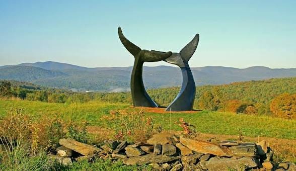
Get off I-89 at Exit 4 in Randolph and there is a McDonald’s, and there is a field, and rising out of that field are two bronze whale tails, sixteen feet tall, diving into the grass.
The sculpture is called Whale Dance. It is the work of Randolph sculptor Jim Sardonis, who has said the whole thing came to him in a dream — two whales breaking the surface, tails in the air — and it has stood on that hillside since July of 2019.
People stop. That is the thing about this spot. It is a highway exit with a fast-food restaurant and a pull-off and a little rest area, and travelers who already got what they came for will park anyway and walk out toward the tails and stand there a while. They take the picture. Everyone takes the picture.
And in every one of those photographs, behind the whales, holding the entire horizon, is a long green ridge.
Ask anyone what they are looking at and they will tell you the Green Mountains. The photo captions say it. The newspaper picture galleries say it. One of the top reviews of the site on Google says it.
There is hardly a single Green Mountain in that view.
What you are actually looking at
Stand where the whales are, face the ridge, and run the skyline. Every peak on that horizon — Braintree Mountain, right around 3,000 feet. Skidoo. Twin Peaks. Riford Hill. Rochester Mountain. Mount Cushman. Deer Mountain.
Not one of them is a Green Mountain.
The Greens are real, and they are big, and they are somewhere else. Swing far enough to the south and Killington will eventually turn up — thirty-odd miles out, sitting low on the skyline even though it is Vermont's second-highest peak. That is what distance does. It is not what you are photographing.
What you are photographing is a different range entirely. It has its own name, and here it is:
The Northfield Range.
The U.S. Geological Survey prints it right on the topographic map: Northfield Mountains. The state’s forestry department calls it the Northfield Range in its own management documents. This is not a nickname somebody invented around a woodstove.
It is printed exactly once.
The mountains nobody can name
Follow the ridge south from that one label and the map goes quiet. The mountains keep going — roughly twenty-five miles of them, south from the Winooski River, past Braintree Mountain, down to Mount Cushman above Rochester — and the name never appears again. Mapmakers label a range where there is room on the page, not where it ends. So the ridge simply continues, unlabeled, and no map will tell you when you have left it.
Which is how you get this: the backcountry skiers who use the southern end call it the Braintree Range. That name appears on no federal map. They seem to have made it up, apparently without knowing the mountains already had a name.
The north end, at least, is easy. The Northfield Range runs to the Winooski River and stops, because rivers are honest about these things. On the far bank, the Worcester Range takes over.
The south end is a shrug.
Its high point is Rice Mountain, in Roxbury, and even that is unsettled. The state’s forestry department puts Rice Mountain at 3,060 feet. Roxbury’s own town plan says 3,086. Twenty-six feet apart, and nobody has bothered to reconcile the two — because in a century and a half, nobody has needed to.
How does a mountain range hide?
Twenty-five miles of mountains, running straight up the middle of Vermont, right there in the photograph behind the whales. It is not small. It is not far away. It is the first thing your eye lands on.
It hides because it has none of the things that make Vermonters look at a mountain.
No Long Trail. The Long Trail runs the spine of the Green Mountains, one valley west. No Long Trail means no Green Mountain Club, no thru-hikers, no century of people writing about it.
No national forest. The Green Mountain National Forest boundary stops short of it.
No ski area. Sugarbush and Mad River Glen are on the other ridge. Everybody drives past the Northfield Range to get to them.
Almost no trails at all. Roxbury State Forest drapes thousands of acres across the eastern slope of this range and has exactly one maintained trail — a short walk to a dam the Civilian Conservation Corps built in the 1930s. Everything else up there is unmarked backcountry.
Nobody argues about where the Northfield Range ends. There is no resort, no trail club, no chamber of commerce with a stake in the answer. The boundary is undefined because the range is unloved.
So it has spent a century being the thing behind the thing — the green wall in the picture of the barn, the church, the covered bridge, the whale tails. It is what Vermont looks like. And we have been calling it by the wrong name the entire time.
Somebody noticed
Vermont has been buying this ridge.
Quietly, in pieces, over years, and largely with federal money. This month the state added 347 acres at Rice Mountain — picking up 1.6 miles of the range’s ridgeline — with a grant from the federal Forest Legacy Program and The Conservation Fund as partner. Fifty-two acres came in from Warren last year. Roxbury State Forest took on another 108 acres in 2022. There is more, and it is still going.
The official reasons are always some version of the same reason: headwater streams, wildlife habitat, unbroken forest. “These additions strengthen the many public benefits Vermont’s State Forests provide,” Kate Sudhoff, the state’s land conservation program manager, said when the Rice Mountain deal was announced.
But read a little further into the announcement and the state says something quieter, and much funnier. These are remote ridgelines, it explains — steep terrain, hard conditions, no infrastructure. Lands, in its words, generally not suited for residential or commercial development.
Which is to say: the state is conserving land nobody was ever going to build on.
That is not a knock. It is the whole point. The Northfield Range is being protected for precisely the reason it was ignored. It is long, it is intact, it is inconvenient, and almost nobody wanted it — which makes it, in the language of conservation planning, a corridor. A moose does not care whether a ridge has a chairlift. A moose cares whether it can walk the length of it without crossing a road.
Vermont has committed to conserving 30 percent of its landscape by 2030. It turns out a long quiet ridge that nobody hikes, nobody skis, and nobody can quite name is exactly the kind of place where a promise like that gets kept.
Look past the tails
Next time you take the Exit 4 ramp and somebody in the car yells whale tails — and somebody will — go ahead and stop. Get the fries. Walk out into the field. Take the picture.
Then take one more second and look past the whales, at that green ridge you have been calling the Green Mountains your entire life.
It isn’t. It is a mountain range of its own. Twenty-five miles of it. It has a name, printed once, on one map.
And most of it is quietly becoming public land while nobody watches.
Compass Vermont is independent and reader-supported.
not to be nit picky but all the Adirondacks and White Mountains, as well as most of the Green Mountains are within 100 miles, and there are many mountains higher than Killington located elsewhere within that radius