

A Peaceful Day of Fishing Becomess a Frightening International Incident Where the Truth Itself is Up for Debate.
The incident has sparked outrage in Quebec and raised questions here in Vermont, not just about jurisdiction, but about the nature of reality itself.
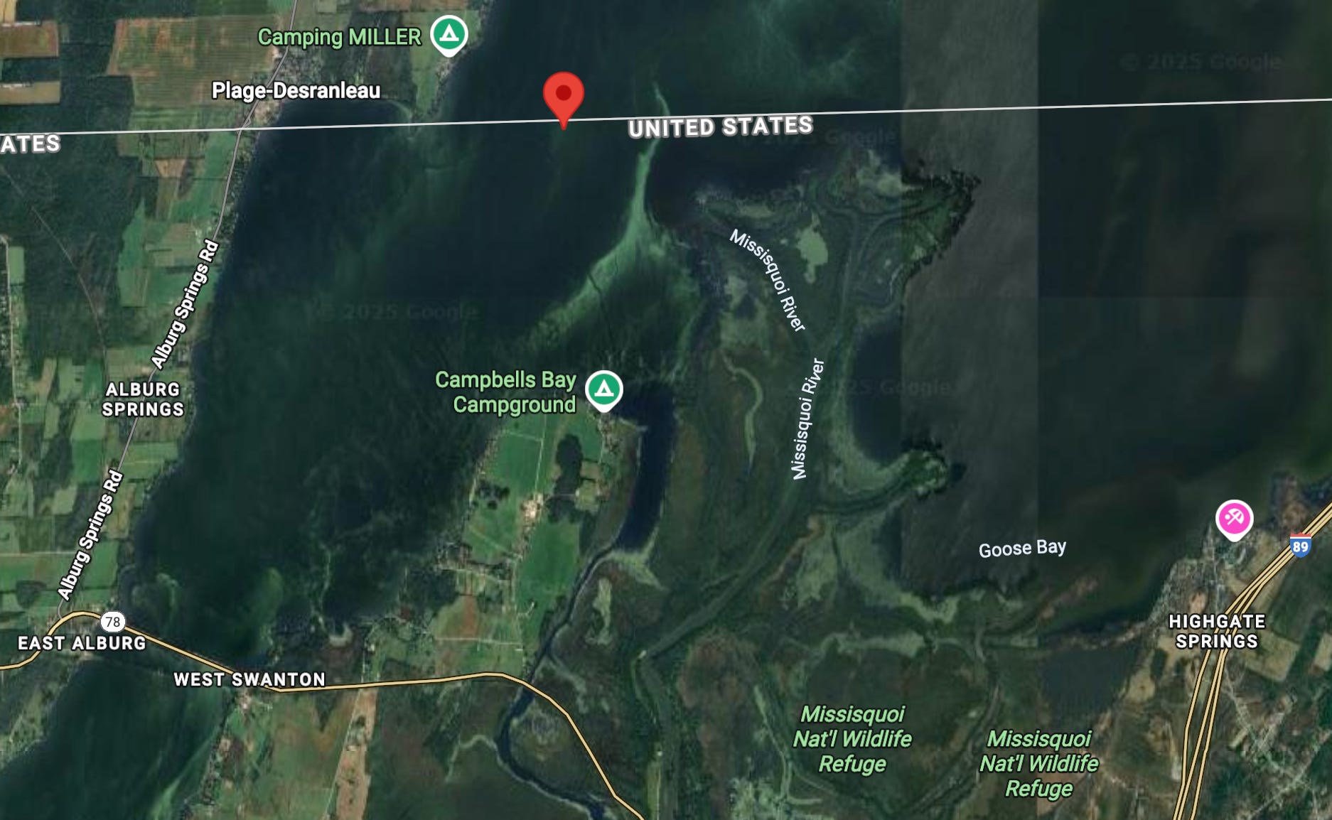
On the vast, open waters of Lake Champlain, the line separating the United States and Canada is an invisible thread, a concept of longitude and latitude drawn over waves. For Edouard Lallemand, a 60-year-old Quebecer, that invisible line became brutally real on Sunday, July 20. An afternoon of fishing near his home in Venise-en-Québec ended with his boat capsized, his body scraped, and his liberty temporarily revoked by the U.S. Coast Guard.
The incident has sparked outrage in Quebec and raised questions here in Vermont, not just about jurisdiction, but about the nature of reality itself. At the heart of the matter lie two starkly different narratives, one from the fisherman and one from the federal officers, that are so contradictory it is difficult to imagine they describe the same event. How, on a quiet Sunday on the lake, can two stories be so different?
The Two Narratives
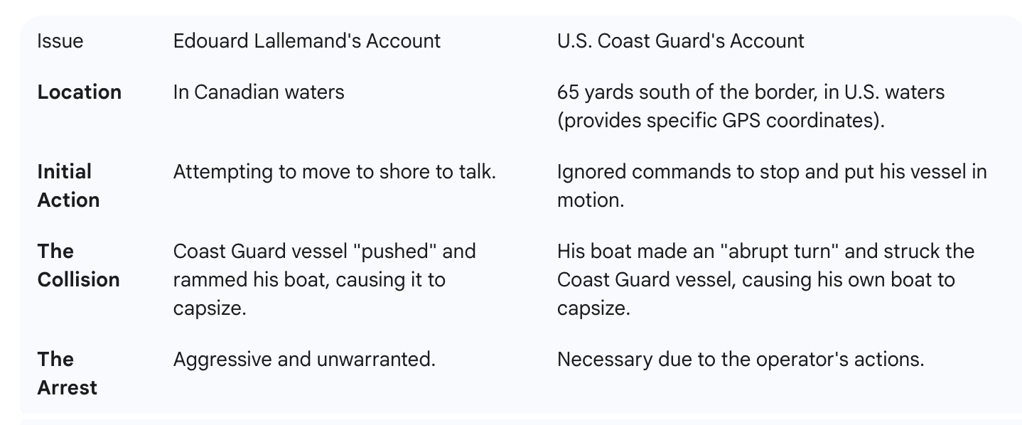
In his telling of the events, Mr. Lallemand, a man who says he has fished these waters for decades, was firmly on the Canadian side of the border. He claims that when a U.S. Coast Guard vessel approached, he attempted to move closer to the shore to facilitate a conversation. It was then, he alleges, that the Coast Guard boat aggressively pursued and "pushed" his smaller vessel, causing it to capsize. He described being pulled from the water, handcuffed, and held for nearly two hours in a cell at the U.S. Customs and Border Protection station in Swanton before his release. "I want an apology," he told reporters, citing the scrapes he sustained and the humiliation of the ordeal.
The U.S. Coast Guard offers a fundamentally different account. In a statement, they maintain Mr. Lallemand’s boat was in “U.S. Customs waters” when they made contact. They allege that when they initiated a routine inspection, Mr. Lallemand put his vessel in gear and ignored commands to stop.
Crucially, the Coast Guard provided precise coordinates for the encounter: 45°00.792'N, 073°10.608'W. According to navigational charts, this position is approximately 65 yards south of the 45th parallel—the international boundary. At this location, the Coast Guard claims, it was Mr. Lallemand’s boat that made an “abrupt starboard turn and struck the port bow of the Coast Guard small-boat,” causing his own vessel to overturn. They have stated his actions are now under investigation.
The core of the disagreement can be broken down as follows:
The Law and the Line
For Vermonters who share the lake, the incident touches on a well-known but often unstated reality. While the border is a friendly one, it is also a hard, legal boundary. The central clue to understanding the conflicting narratives may lie in the regulations governing the lake itself.
An angler with a Vermont or New York fishing license can fish in much of the other state’s waters on the lake, thanks to reciprocal agreements. However, that reciprocity does not extend to Quebec. A Quebec fishing license is not valid in the U.S. portion of Lake Champlain.
If the U.S. Coast Guard's coordinates are accurate—and GPS technology is a standard tool of their trade—then Mr. Lallemand was not only in U.S. waters but was also fishing there illegally. This fact provides a potential explanation for why an otherwise routine inspection might escalate. While Mr. Lallemand insists he was in Canada, the Coast Guard's data suggests a different reality, one that would have placed him in violation of U.S. law.
As of this writing, neither Global Affairs Canada in Ottawa nor the U.S. State Department in Washington has issued a formal statement on the matter. The legal outcome for Mr. Lallemand also remains unknown.
What happened on the water that Sunday afternoon will likely be determined by data, video evidence, and sworn testimony. But the incident serves as a stark reminder that on Lake Champlain, our shared backyard, a few dozen yards of open water can mean the difference between a peaceful day of fishing and a frightening international incident where the truth itself is up for debate.
Consider current ICE's and the president's lawless behavior (and serial Lies) any testimony from a us authority is to be taken with several grains of salt. I would believe a simple fisher over any us "authority"
“If the U.S. Coast Guard's coordinates are accurate—and GPS technology is a standard tool of their trade—then Mr. Lallemand was not only in U.S. waters but was also fishing there illegally.”
No. 45°00.792'N, 073°10.608'W Is by definition north of the 45th parallel that defines the border, it is 0.792’ north in fact, and therefore in Canada. That would make their location north of and outside of the U.S.
If the U.S. Coast Guard’s coordinates are accurate, they were not in U.S .territory at the time of the initial encounter; they were out of jurisdiction, outside of the bounds of the law and in the wrong.